 By Leonard David
SPACE.com
High on Mount Ararat in eastern Turkey, there is a baffling mountainside "anomaly," a feature that one researcher claims may be something of biblical proportions.
. . .
Images taken by aircraft, intelligence-gathering satellites and commercial remote-sensing spacecraft are fueling an intensive study of the intriguing oddity. But whether the anomaly is some geological quirk of nature, playful shadows, a human-made structure of some sort, or simply nothing at all remains to be seen.
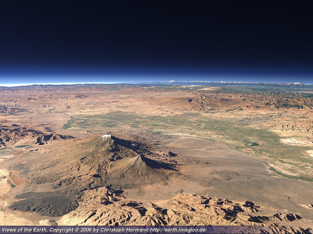
Whatever it is, the anomaly of interest rests at 15,300 feet (4,663 meters) on the northwest corner of Mount Ararat, and is nearly submerged in glacial ice. It would be easy to call it merely a strange rock formation.
But at least one man wonders if it could be the remains of Noah's Ark, a vessel said to have been built to save people and selected animals from the Great Flood, the 40 days and 40 nights of deluge as detailed in the Book of Genesis.
The Genesis blueprint of the Ark detailed the structure as 6:1 length to width ratio (300 cubits by 50 cubits). The anomaly, as viewed by satellite, is close to that 6:1 proportion.
Newfound optimism
Identifying the Ararat anomaly has been a 13-year quest of Porcher Taylor, an associate professor in paralegal studies at the University of Richmond's School of Continuing Studies in Virginia.
Taylor has been a national security analyst for more than 30 years, also serving as a senior associate for five years at the Center for Strategic and International Studies (CSIS) in Washington, D.C.

"I've got newfound optimism ... as far as my continuing push to have the intelligence community declassify some of the more definitive-type imagery," Taylor told SPACE.com/LiveScience. He points to a "new and significant development," a high-resolution image taken by DigitalGlobe's impressive QuickBird satellite and shown here publicly for the first time [alternate version with no annotation].
"I'm calling this my satellite archeology project," Taylor said. It's an effort that has now included use of QuickBird, GeoEye's Ikonos spacecraft, Canada's Radarsat 1, as well as declassified aerial and satellite images taken by the various U.S. intelligence agencies.
Making the mountain transparent
Taylor said his goal is straightforward: Combining this imagery to make the Ararat anomaly transparent to the public, as well as to the discerning, dispassionate eyes of scientists, imagery analysts, and other experts.
"I had no preconceived notions or agendas when I began this in 1993 as to what I was looking for," Taylor said.
As for the saga of Noah's Ark, he is quick to note that there are those who say it is fable while some take it as truth.
Nevertheless, the anomaly may not be a ridge line of ice, snow and possibly rock, but an artificial ridge line, Taylor said. "I maintain that if it is the remains of something manmade and potentially nautical, then it's potentially something of biblical proportions."
While chiding the intelligence communities to release more of their closely guarded satellite imagery, Taylor said that soon-to-fly commercial remote sensing spacecraft are sure to help his archeological undertaking.
"We've got three new birds that are going up. I'm using all my clout, rapport and lobbying to, hopefully, have them at least fly calibration runs over Mount Ararat," Taylor said. Those images would make the mountain even more transparent, he said.
Will it float?
Meanwhile, Taylor has an ever-expanding network of experts to help tease out the truth about the anomaly.
For example, satellite imagery analyst Rod Franz of SunTek Media Group/RiteImage, Inc., located in Henderson, Nevada, has taken a look at imagery provided by Taylor of the Ararat anomaly and carried out additional analysis of the area. As director of training for the firm, Franz sharpened his skills by serving nearly 25 years as a military intelligence imagery analyst.
For the anomaly assessment, the same software tools used for studying government and commercial remote sensing data were employed, Franz told SPACE.com/LiveScience. Ground distances and scales of the anomaly were determined. That software also has the ability to adjust brightness, haze, sharpness, contrast and other factors of the area of interest, he said.
"Along with many other image manipulation functions ... I also used the pseudo-color function trying to determine if I could detect anything under the ice and snow," Franz said.
The face of the anomaly measured 1,015 feet (309 meters) across, Franz said. "I also found the shape of the anomaly appears to fit on a circle. I am not sure what this means, if anything, but I find it curious."
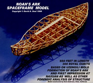
Given that length, Taylor pointed out, the anomaly dwarfs the Titanic and Bismarck in size, and equals the size of the largest modern aircraft carrier. That analysis would seem to call into question whether the anomaly is a wooden ship and raises a key question: If a boat were truly that huge, would it float?
There are also experts in remote sensing who offer a skeptical view. "Image interpretation is an art," said Farouk El-Baz, Director of the Boston University Center for Remote Sensing.
"One has to be familiar with sun lighting effects on the shape of observed features," El-Baz said. "Very slight changes in slope modify shadow shapes that affect the interpretations. Up to this time, all the images I have seen can be interpreted as natural landforms. The feature that has been interpreted as the 'Ararat Anomaly' is to me a ledge of rock in partial shadow, with varied thickness of snow and ice cover.
Visual truth serum
Thanks to more satellite imagery in the offing, as well as other studies under way, Taylor said his remote archaeological research is on the upswing.
There is an ultimate end-game. That is, on-the-spot ground truth --and Taylor hopes his research findings will catalyze a top-notch expedition to the area. "It is whatever it is," he said.
But for now, satellite remote sensing to carry out archaeological "digs" from space will fill in for an in-the-field expedition.
Just a few weeks ago, for example, NASA scientists utilizing space- and aircraft-based remote sensing hardware and techniques uncovered Maya ruins hidden in the rainforests of Central America for more than 1,000 years.
"For explorers, imagery from GeoEye's Ikonos satellite married with Global Positioning System (GPS) satellite data has become as indispensable as water and freeze-dried food for any expedition. One does not want to leave home without it," said Mark Brender, GeoEye vice president for communications and marketing, headquartered in Dulles, Virginia.

For researchers, images from space like those provided by GeoEye provide "the ultimate high shot" and a contextual view that couldn't be had from observations on the ground or even from a plane, Brender told SPACE.com/LiveScience.
"It's visual truth serum."
Mount Ararat

Ararat is located at Agri in eastern Turkey near the Russian and Iranian borders. As the crow flies, it is about 250 kilometers east of Erzurum, 130 kilometers southeast of Kars, and 160 kilometers north of Van. The main road between Turkey and Iran goes from Erzurum through Dogubayazit (just south of Ararat) to Tabriz. The summit of Mt. Ararat is 5,165 meters above sea level. It is higher than any mountain in the continental United States except for Alaska or in Europe outside the Caucasus.
Ararat is a dormant volcano; the last eruption was on June 2, 1840. At present the upper third of the mountain is covered with snow all the time; the last hundred meters of snow at the top have turned to ice. For climbers on the mountain, fresh running water is available after the sun has been up a while to melt the snow, but it is cut off in the late afternoon when cold air has overcome the heat of the sun. Below the snow the slopes are covered with great blocks of black basalt rock, some as large as village houses.
Over the years various groups have explored Ararat in the hopes of finding remains of Noah's Ark. Both Josephus in about 70 A.D. and Marco Polo about 1300 A.D. mention its existence on the mountain, but their reports are based on others' accounts. Josephus remarks that its remains are on display for all to see without need of an organized exploration. In more recent years many groups have hunted for it there. The possibility that ancient fables are historical fact is intriguing, and each new discovery of truth in previously discredited records gives additional strength to continuing the search for archaeological confirmation.
However, the problems of establishing exactly what the biblical record in this case means are serious ones that need to be settled even before one accepts this particular high mountain as the right place to look for the ark. In itself even that ignores the possibility that Noah and his family used up the ark in bits and pieces to build their new homes, a fate that has destroyed many other famous structures in the Near East since.
The story of Noah's ark, as it is told in the Bible, is a reworking of an earlier Babylonian myth recorded in the Gilgamesh Epic. The hero of the earlier version is one Utnapishtim, the favorite of Ea, the god of wisdom. It seems probable that the Babylonian story was based on an unusually devastating flood in the Euphrates (Firat) River basin, and that the ark in it grounded on the slopes of one of the Zagros mountains. The biblical word that we read as "Ararat" could as well be read "Urartu"; the text has merely "rrt" and the proper vowels must be supplied.

Urartu was the name of a historical kingdom, but the word also meant "a land far away" and "a place in the north." So, while Buyuk Agri Dagi is a spectacular mountain and not a difficult one to climb for those experienced in high altitude exercise, it still seems less than likely that Noah's Ark will be found there. That doubt does not detract from the continuing interest in it, nor from the important achievements of archaeologists in deepening our understanding of the Old Testament.
On the north side, Ararat has its roots in the Araxes (Aras) River valley. There it rises from the valley elevation of about 760 meters above sea level. In that area the Araxes River is the border demarcation between Turkey and Russia. The top of the mountain is only about 30 kilometers from the border. For some years both the Turkish and the Soviet governments have been touchy about foreigners exploring on Ararat because of military security precautions. Therefore it was difficult to get permission to climb it for sports fans. On 1st of November 2004 Ararat Mountain and surroundings were declared as the 35th National Park of Turkey by the Government so it's believed that it will attract more visitors and help to the local economy as well. So far there are no ski resorts on the mountain but you never know, maybe one day... The nearest one is on Bubi Mountain which is open from December till April.
If one has that permission, it is best to plan the trip starting from Dogubayazit on the south, a saving of more than a kilometer in climbing. One can start from Dogubayazit by jeep or sturdy station wagon, traveling across the valley to the base of the mountain where pre-engaged local guides will meet the party. The average hiker who is experienced in high altitudes can make the climb in three days, but it is better to plan four days to allow for exploration of the top. Late August is the best season.
www.allaboutturkey.com
Famous in the Bible as the final resting-place of Noah's Ark, Mount Ararat has been wreathed in legends for millennia.
Its two peaks, Great Ararat (Büyük Agri, 5137 meters/16,854 feet) and Little Ararat (Küçük Agri, 3895 meters/12,779 feet) were revered by the people of ancient Urartu (13th to 7th centuries BC), who gave their name (Urartu = Ararat) to the mountain. The nearest town to the mountain is Dogubayazit. When permits are granted for climbs up the mountain, the treks depart from here.
The Sumerian Epic of Gilgamesh (c. 2000 BC) describes a great flood, as does the later record of Berossus (3rd century BC), and of course the Bible (Genesis and Gospels) and the Kur'an.
In the story, a flood lasting 40 days and nights wipes out all living things except those in a boat or ark built, on orders of God, to survive The Deluge. In the ark are male and female representatives of each species, including Noah, his wife and family.
Recent marine archeological research in the chill, deep waters of the Black Sea has revealed sunken cities on the underwater slopes along the Turkish coast.
Geological evidence supports the theory that in ancient times the northern end of the Bosphorus was blocked by earth and rock. The Black Sea had no outlet (like Lake Van today), and its water level was below that of the Aegean Sea, the Sea of Marmara, and the Bosphorus.
However, an earthquake destroyed the Bosphorus blockage, releasing a deluge of water from the Bosphorus into the Black Sea, raising the water level and flooding its coastal communities.
Were there characters like Noah who saw the flood coming and built boats to survive? We may never know. What does seem far-fetched is that any of the boats came to rest on the slopes of Ararat, which is a long way from the Black Sea.
This has not deterred ark-hunters, who have trekked up Ararat over the years in search of Noah's Ark. The most famous expedition was that led by ex-US Astronaut James Irwin in 1982.
In 1985 an expedition led by David Fusold discovered a boat-shaped stone formation on a nearby mountain called Musa Dagi ("Mount Moses") east of Dogybayazit near the village of Üzengili. Using ground-penetrating sonar, Fusold mapped the site and produced intriguing but inconclusive evidence that the stone formation was anything more than a curious stone formation.
Want to go look for yourself? It's not easy. Although guided treks up Mount Ararat were allowed during the 1970s, after several grim incidents the government forbade them because of very real danger from smugglers and other outlaws, Kurdish terrorists, severe weather and wild beasts.
Contact a Ministry of Tourism office to find out what the current permit situation might be.
www.turkeytravelplanner.com


0 comments:
Post a Comment
Please Update/Correct Any Of The
3700+ Posts by Leaving Your Comments Here
- - - YOUR OPINION Matters To Us - - -
We Promise To Publish Them Even If We May Not Share The Same View
Mind You,
You Would Not Be Allowed Such Freedom In Most Of The Other Sites At All.
You understand that the site content express the author's views, not necessarily those of the site. You also agree that you will not post any material which is false, hateful, threatening, invasive of a person’s privacy, or in violation of any law.
- Please READ the POST FIRST then enter YOUR comment in English by referring to the SPECIFIC POINTS in the post and DO preview your comment for proper grammar /spelling.
-Need to correct the one you have already sent?
please enter a -New Comment- We'll keep the latest version
- Spammers: Your comment will appear here only in your dreams
More . . :
http://armenians-1915.blogspot.com/2007/05/Submit-Your-Article.html
All the best